Resources for Students and Instructors
Academic Case Studies: National ITS Architecture Component 2 Study Exercise
The following is an exercise that will allow you to explore the National ITS Architecture contents while following a process that state and local planning organizations use as part of their ITS planning activities. You will develop ITS architecture information to guide the deployment of ITS for a major university event trip generator – a Saturday afternoon football game. Instructions about each of your tasks follow the description below. You will develop a document recording your findings and answering the questions within the tasks.
YOUR ROLE
You are a new traffic engineer at the City’s department of transportation (City DOT). Your job responsibilities to this point have included traffic studies, data collection, traffic signal timing, and numerous other tasks. Your supervisor has been a City DOT engineer for 20 years and did all the same type of work you are doing now. However, with recent technological advancements in the traffic and transportation field, some new approaches to how the City manages its transportation system have been introduced. While your supervisor understands the benefits of this approach, there is apprehension about how it all works.
DESCRIPTION
A football game represents the biggest event that your City has to accommodate. There are typically six to seven home games a year, each drawing close to 80,000 people into the City on game days. The university campus is located in the middle of your City. However, its football stadium is located off-campus, about two miles from the heart of campus.
In the past 15 years, traffic conditions on home game weekends have degraded each year. As the team has improved under new leadership, attendance has grown which has steadily increased car traffic and the tail-gating activities prior to and after game time. In turn, this has increased the congestion and spread it over a longer period of time.
To capitalize on this new found vigor for the football program, the University made a commitment to expand the stadium to accommodate an additional 15,000 seats. Thus, the record draw of alumni and fans to the games is only expected to increase as the stadium is expanded for more seats.
Once it was decided to expand the stadium, the University commissioned a study to assess the current and future demand being fueled by the record attendance. The study concluded that traffic conditions will not improve unless new roadway access and traffic management features are put in place. The roadway expansion is severely limited due to the unavailability of land for new roads around the stadium; therefore, using traffic technology is imperative.
Since the stadium sits off-campus and is surrounded by City-maintained streets and traffic signals, the University approached the City DOT engineer (and you) with their stadium expansion plans and completed traffic impact study. The study recommended a plan be developed to handle traffic before, during, and after the game on the campus grounds, the stadium grounds, the freeways, arterials, and local streets that surround the stadium and used for ingress and egress. The study made it clear that an overhaul of the existing City’s Traffic Management Center (TMC) would be needed in order to implement and use any ITS devices.
As you are painfully aware, traffic leading to and away from the stadium is under the control of the City Department of Transportation. Around the stadium, the City police department usually handles special traffic control providing travelers with direction as they enter and exit the area. It was recommended that traffic be directed by dynamic message signs at key locations to reduce police activities and to provide game day information, e.g., recommended exits, parking direction, etc., to those approaching the stadium via freeway. It was proposed that 6 portable dynamic message signs (DMS) be placed at key locations along arterials approaching the stadium and 2 overhead DMS’s be installed on the freeway in advance of the exits providing main access to the City and stadium. In addition, the study recommended that the City TMC provide traveler information via radio, website, and a mobile app to inform travelers of traffic conditions and provide routing based on current traffic conditions. Any new devices placed on the freeway will require coordination with the State DOT.
The study also recommended the implementation of vehicle detection/surveillance devices at 10 intersections, on two main arterials (8 locations total), and at four locations on the freeway that would feed traffic data to the upgraded City TMC, providing a clear picture for operators of the status of the roadways.
In addition, to better coordinate incident response, the City police will have an officer located in the City’s TMC on game days to better coordinate incident response. Video surveillance will be monitored from the TMC center allowing the officer to assess incidents within view of the nearest camera and directly dispatch response.
One of the findings in the study was the lack of information provided to motorists about parking. Parking is available on the University campus, as well as, in City and public lots. Parking area locations are ill-defined and occupancy levels unknown causing a lot of wasted travel and congestion. It was recommended that parking information be disseminated using technology so the public will know the locations of designated parking areas and the number of spaces available at each. Two major parking areas were designated as test beds for parking occupancy detection.
Transit service provided by the City Transit Authority will receive traffic conditions at the existing Transit Management Center. It was recommended that two special transit routes be provided on game days and that flexibility be built into the system to best serve the riders. This would entail some type of technology being implemented on 4 buses. Furthermore, the university operates 4 shuttle buses from on-campus parking areas to the stadium. It was recommended that transit options be coordinated between the City Transit Management Center and the existing University Shuttle Dispatch Center.
The university will make a sizeable investment in technology to accomplish this deployment. It will be accomplished over a period of 3 years. The City, recognizing the importance of improving traffic conditions on game days, has agreed to devote funds for these improvements out of their annual transportation budget over the same 3-year period. The costs associated with each ITS component, the subsequent TMC upgrades, the implementation and integration of the ITS technology, and the operation and maintenance costs of the system, all need to be considered in order to determine how to phase the project, i.e., based on your budget constraints each year, how will you stage your ITS technology deployments. Therefore, an ITS architecture is needed to properly plan and coordinate each phase of the deployment.
Table 1 provides a summary of the proposed ITS elements recommended for the project. It should be noted that the existing TMC will need to be upgraded to accommodate the new ITS devices shown in this table.
|
Table 1 Summary of Project ITS Elements
|
|
ITS DEVICE TYPE
|
NUMBER OF DEVICES
|
|
Portable Dynamic Message Sign (DMS)
|
6 signs
|
|
Overhead DMS
|
2 signs
|
|
Vehicle Detection/Surveillance Cameras
|
10 Intersections (40 cameras)
2 arterials (8 cameras)
1 Freeway (4 cameras)
|
|
Parking Detection Systems
|
2 Parking Locations (one City-owned, one University-owned)
|
|
Transit Technology Upgrade
|
4 City buses
4 University shuttles
|
|
Mobile App
|
1 app for motorists
|
The following is a summary list of the agencies involved in the project.
- State Department of Transportation
- City Department of Transportation/TMC Operators
- City Transit Authority
- City Parking Department/City Parking Operators
- City Police Department
- University Department of Transportation
- University Transit Department
- University Parking Department
- University Police Department
In the following tasks, you will begin the development of an ITS architecture and/or its major components reflecting primary capabilities described above using the National ITS Architecture website local.iteris.com/arc-it/ as a guide.
Task 1: Subsystem Mapping – Take some time to explore the National ITS Architecture at local.iteris.com/arc-it/. To start with, review the Physical Architecture at http://local.iteris.com/arc-it/html/viewpoints/physical.html- content is no longer available. Subsystems, the primary components of the physical architecture, are generic representations of systems. The first step in creating an ITS architecture is to associate local systems with the subsystem(s) of the National Architecture (based upon the best fit). Typically, one-to-one associations are desired but a system that performs varied functions may have to be mapped to two or more subsystems.
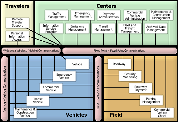
Click on the “Subsystem Interfaces Diagram” tab and review the diagram. Then click on the various subsystems identified in the diagram (as white boxes) to get acquainted with the definitions and scope of each subsystem. After reviewing the information, complete the following tasks and record in Table 2:
- Using the project description above, identify the primary systems involved (listed in Table 2) and characterize them as either existing or planned.
- Identify the organization that owns and/or operates the system.
- Determine which subsystems best match the systems you have identified from the project description and associate (i.e., map) the system to the appropriate subsystem(s).
|
Table 2 ITS System Mapping
|
|
SYSTEM IN PROJECT
|
STATUS
|
ORGANIZATION
|
SUBSYSTEM MAPPING
|
|
City Traffic Management Center
|
Existing (& planned)
|
City DOT
|
- Traffic Management Subsystem
- Information Service Provider Subsystem
|
|
dynamic message signs
|
planned
|
City DOT
|
|
|
personal devices (radios, computers, tablets, cell phones, etc.)
|
|
|
|
|
vehicle detection devices
|
|
|
|
|
parking monitoring equipment
|
|
|
|
|
City Transit Management Center
|
|
|
|
|
City transit vehicle equipment (tracking, etc.)
|
|
|
|
|
University Shuttle Dispatch Center
|
|
|
|
|
video surveillance cameras
|
|
|
|
|
City Police Dispatch System
|
|
|
|
Finally, answer the following questions:
- Do the systems needed for this Project map to only one subsystem or multiple?
- When a system maps to multiple subsystems in the architecture what might the technical and institutional implications be for the project?
- Are there functions of some of the subsystems (to which you mapped systems) that are not necessary for this project? If so, give one example.
- What additional subsystems do you think could be potentially useful to implement in the future? Why? Provide your potential additional subsystems answers in Table 3.
|
Table 3 Potential Additional Subsystems
|
|
SUBSYSTEM
|
POTENTIAL FUTURE USE
|
|
|
|
|
|
|
|
|
|
|
|
|
Task 2: Service Mapping – In the project description there are activities or (that is, activities to be performed by the systems) identified which are needed for the project.
- Explore the Service Packages in the National ITS Architecture (available on the Service Packages tab of the National Architecture website, http://local.iteris.com/arc-it/html/servicepackages/servicepackages-areaspsort.html). The service packages are grouped by area such as traffic management, traveler information, etc. For the list of services in Table 4 involved in the project, identify the relevant Service Package(s) for each service. (At this time only complete the second column of the table. The third and fourth columns will be completed during Task 5 of the exercise.) A service for the project may require more than one service package from the National ITS Architecture to accomplish it fully.
When the mapping is completed, answer the following questions:
- Service packages identify subsystems that may potentially be involved in a service. Can you name a subsystem included in the ATMS-08-Traffic Incident Management System service package that was not identified in Task 1?
- What do the service packages provide beyond the subsystem mapping you did in Task 1?
|
Table 4 ITS Service Mapping
|
|
TO BE COMPLETED IN TASK 2
|
|
TO BE COMPLETED IN TASK 5
|
|
SERVICE OF PROJECT
|
RELEVANT SERVICE PACKAGE(S) FROM NATIONAL ITS ARCHITECTURE
|
|
OBJECTIVE(S)
|
PERFORMANCE MEASURE
|
|
Upgrade Existing City TMC
|
- ATMS01 – Network Surveillance
- ATMS03 – Traffic Signal Control
- (These answers are provided as an example to help students start exercise.)
|
|
- Increase the percent of regional transportation system monitored by the TMC for real-time performance.
- Improve average travel time during peak periods by X percent by year Y.
|
- % of regional transportation system monitored by the TMC.
- Average travel time during peak periods (minutes).
|
|
Traveler information provided by dynamic message signs
|
|
|
|
|
|
Traveler information provided via radio, website, and a mobile app by traveler information system
|
|
|
|
|
|
Traffic data collection via traffic detection devices
|
|
|
|
|
|
Parking Occupancy Information
|
|
|
|
|
|
Dissemination of parking information including parking availability
|
|
|
|
|
|
Flexible transit service (based upon monitoring of traffic conditions by Transit Management Center)
|
|
|
|
|
|
Technology on buses
|
|
|
|
|
|
Coordination of transit options by City and University Shuttle
|
|
|
|
|
|
Coordinated incident response by City Police
|
|
|
|
|
Task 3: Define the Project – Services or groups of services are often all that is needed to develop a scope for a project. The service packages may provide you with small projects that can be incrementally deployed. The trick is to figure out what should be installed first.
- What would be your rationale for phasing deployment of the project?
- Prioritize the list of services in order for deployment (from earliest to last). Services can be prioritized by defining the exact order in which the services will be deployed or, more frequently, services are categorized in deployment timeframes (such as, short- term, mid-term & long-term).
- How would you involve the many different agencies, institutions, and organizations listed in the Description section of this exercise in the project development?
Task 4: Plan the Project – The project definition you have developed won’t become a reality unless funds are available to implement it. The reality of transportation projects and especially ITS projects is that their deployment often requires that the project be broken into smaller pieces based on the functionality required over time dictated by the available funding. For this task, assume the following funding plan:
- Year 1 - $450,000
- Year 2 - $350,000
- Year 3 - $250,000
These funds represent the combination of funds allocated in the City’s transportation plan and contributions from the University over the next 3 years. This funding can be used only for capital improvements including ITS but is not to be used for operations or maintenance resources at the City. You must assume that no more City staff can be added to operate the signal system that is currently in place.
Given the information above, your task is to develop a cost sheet for Year 1. The cost sheet should list the following items:
- The systems or ITS components you have determined should be implemented in Year 1 of the project
- The costs incurred by each component or system implemented in Year 1.
A key factor in this type of planning, especially when the project you are working on requires integration of ITS components, is accommodating the functionality dependencies of the systems/components being implemented. These dependencies should be evident in your plan in the way you phase the project implementation in the first year of the project. (Obviously in the real world you would be required to fiscally plan out all 3 years, but for purposes of this exercise, you need only to consider Year 1. Keep in mind though, in order to determine the ITS components you need for Year 1, you still need to think about the most logical way to phase in the ITS technology over three years.)
To assist you in developing a cost sheet, Table 5 has been provided listing common ITS components along with their respective capital costs and operating and maintenance costs (just ignore the O&M costs and use only the capital costs when creating your cost sheet, O&M costs will be addressed later in this task). Note that the purpose of Table 5 is to provide a starting point and is not all-inclusive. There may be other ITS components you need that are not listed here; use the ITS cost database at the link given above to find costs for other components you may need.
| Table 5 Common ITS Component Costs |
|
ITS COMPONENT
|
CAPITAL COST ($K)
|
O&M COST ($K/YEAR)
|
NOTES
|
|
Dynamic Message Sign (portable)
|
21
|
1.6
|
Per unit
|
|
Video Camera Sensor on Corridor
|
24
|
0.3
|
Two sensors, one in each direction of travel
|
|
Video Camera Sensor at Intersection
|
22
|
1
|
Four-way intersection, one camera each approach
|
|
CCTV Video Camera
|
16
|
2
|
Color video with PTZ
|
|
Signal Controller Upgrade
|
12
|
0.4
|
Upgrade signal controller at intersection
|
|
New Traffic Signal
|
92
|
2
|
Installation of a new traffic signal with video detection
|
|
TMC Upgrade
|
300
|
50
|
Upgrading the existing TMC to accommodate new ITS
|
|
GPS for Transit Vehicle Location
|
2
|
0.3
|
Automatic Vehicle Locator per transit vehicle
|
|
Parking Monitoring System
|
35
|
2
|
Includes detection and controllers for parking areas
|
|
Integration of ITS Devices
|
100
|
2
|
Costs pertaining to field work associated with connecting new devices to upgraded TMC
|
Note: For the purposes of this exercise, installation costs are assumed as part of the capital costs.
- When you factored in the costs and funding constraints of the project, did it complicate the project?
- Were there options to implementation available given the funding constraints or was the plan forced into a particular approach? If options were available, what was your thought process for the path you chose?
- Look at the phasing deployment you developed in Task 3 for Question 1. If you had considered the funding constraints from the beginning, would the project have turned out the way you defined it? If not, what do you think would have been different?
- In the cost table above, the Operation and Maintenance costs were listed but you were not asked to include them in your Cost List. O&M costs are very important to consider in the real world - what are these costs and why do they need to be considered?
Task 5: Project Evaluation – The challenge with deploying ITS projects is knowing that what was deployed made a difference or solved the problem that prompted it in the first place.
For this task:
Describe how you would go about evaluating the project after it has been implemented. Expanding the table in Task 2 above, outline an evaluation plan for the evaluation of this project. For the services to be provided in the project, identify the objective to be accomplished by the service and the performance measure(s) that are needed to confirm if the objective is met.
1. Is there particular information that is most valuable for the evaluation to be successful?